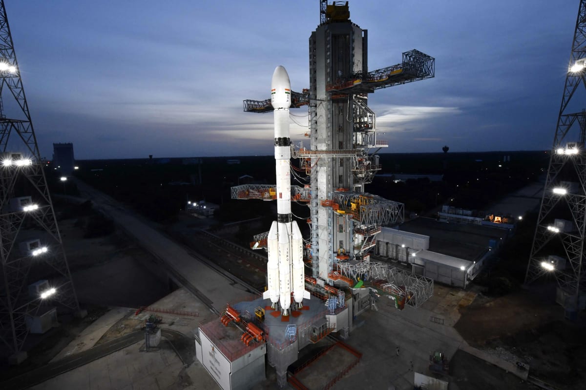
ISRO launched the GSLV-F17 from Sriharikota before dawn on Friday, placing the EOS-05 earth-observation satellite in orbit to strengthen disaster management and surveillance, according to India Today.
The pre-dawn mission, reported by NDTV, carried EOS-05 from the spaceport in Andhra Pradesh. The Times of India described the payload as India's first geo imaging satellite. Prime Minister Narendra Modi welcomed the launch.
The persistence advantage
A geo imaging satellite does not behave like a sensor that sweeps past a target at regular intervals. It can hold a fixed regional view, watching the same stretch of land and sea for long periods instead of blinking through a pass. Disaster management and surveillance both reward sensors that do not blink; that is the core advantage of this mission.
There is a tendency to read every ISRO mission through the lens of prestige. EOS-05 is not best understood that way. The satellite is meant to be used by district disaster cells, state emergency operations centres, and maritime watch stations, not commemorated in a postage stamp. Its value is measured in hours saved between a hazard event and a warning reaching a coastal village.
Disaster response is the first beneficiary
India's eastern seaboard, Himalayan belt, and flood-prone river basins demand rapid remote-sensing data when cyclones, landslides, and flash floods strike. State machinery in Odisha, Andhra Pradesh, and West Bengal has built evacuation drills around early warning; that warning depends on how quickly a storm's track and intensity are known. EOS-05 feeds the National Disaster Management Authority and state agencies with a domestic data stream for early warning and damage assessment.
Cyclone landfalls are not abstract events in the Bay of Bengal. Every hour of advance notice changes how many people can be moved out of a storm surge's path. A persistent sovereign sensor over the Indian landmass and surrounding waters turns that notice into a domestic capability rather than a purchased one.
The practical orientation matters because India's exposure is not uniform. The eastern coast faces cyclones; the Himalayan belt faces glacial lake outbursts and landslides; the river basins face floods. A single persistent sensor cannot solve all of these, but it can provide the raw material on which early warning systems build.
The surveillance dividend
Surveillance is the mission's other stated purpose. India's maritime approaches carry cargo ships, fishing fleets, and naval movements from multiple powers every day. A sovereign imaging satellite that holds a fixed regional view gives India's maritime security establishment a persistent look at sea lanes and coastal approaches without depending on foreign providers.
That matters beyond military planning. Maritime domain awareness feeds search and rescue, oil-spill tracking, and response to smuggling or unauthorised vessels. The same sensor that watches a cyclone build can also watch an unlit boat move toward a prohibited zone; both functions now sit on one domestic platform.
Sovereignty and regional reach
The launch sits inside the Atmanirbhar Bharat objective of reducing dependence on foreign satellite data for civilian and security applications. A domestic imaging sensor over the Indian region means disaster maps, crop assessments, and coastal surveillance no longer depend entirely on buying time from other countries' constellations.
The same platform can extend processed data to Indian Ocean neighbours. New Delhi has long presented space cooperation as a low-cost form of regional goodwill; EOS-05 adds a data layer that can be shared with littoral states under existing outreach frameworks without moving any hardware. That soft-power dividend flows from a single orbital asset rather than from a diplomatic tour or a new aid package.
The ground segment gap
An orbital asset is only as useful as the ground segment that ingests it. District-level officials still work through a fragmented pipeline: raw satellite imagery arrives, gets processed, and then waits for a human in a state capital to interpret it for a flood map or a landslide alert. The launch exposes a structural gap between high-end sensors and last-mile use.
A district collector in north Bihar does not need the same product as a maritime watch officer in the Andaman Sea. The first needs a simple inundation overlay on a revenue map; the second needs vessel detection. EOS-05 can provide the source data for both, but only if the ground segment tailors the output to the user.
Fixing that gap means investing in a public cloud for remote-sensing analytics and training state disaster-management units to ingest EOS-05 products within hours, not weeks. The satellite can deliver the data; the question is whether the block office has the bandwidth and the software to act on it.
Agriculture and the quieter gains
Agricultural monitoring is a quieter gain. The same imagery that tracks a storm can read crop health, irrigation spread, and drought stress across a district. That makes EOS-05 a tool for the farm sector as much as for the emergency operations centre, and it deepens India's technology sovereignty in a sector where data has long been an imported commodity.
Conclusion
EOS-05 is not a one-off launch. It is a building block in the slow, unglamorous work of making India's civil and security institutions less dependent on outside information. The test will come in the next Bay of Bengal cyclone or Himalayan cloudburst, when the data arrives and a district magistrate must decide, on a screen, which village to empty first. Orbital persistence has just improved; the ground still has to catch up.